Uinta backcountry skiing / Hell’s Kitchen ski mountaineering
Uinta backcountry skiing Hell’s Kitchen ski mountaineering trip report, Uinta mountains of Utah. The author and his trusted rottweiler sought out epic ski lines. They were to be turned back by a difficult route. The mountaineers returned the following summer and completed the Hell’s Kitchen route.
With a 2-pm phone call, the window to ski Western Uintas Hell’s Kitchen opened up. I’d been planning to backcountry ski tour HELL’s KITCHEN, for some time. In the winter the Avalanche danger was too high. Now it’s early April, the snowpack is stable, and my window to ski it is open but closing rapidly.
The Uinta Mountains receive a Continental snowpack, compared to the Wasatch InterMountain snowpack, is dryer and doesn’t stick to stuff as well. Consequently, the Uintas regularly have a less stable snowpack with higher avalanche danger. The early April spring conditions have healed the unstable snowpack making it safe/er for me and my rottweiler (Kota), Uinta backcountry skiing Hell’s Kitchen trip, I’ve got the 1.5 days and time is ticking.
Day 1
Winter camping and mountaineering equipment are essential skills for Uinta backcountry skiing. So I pack up the crampons, a -20F sleeping bag, a 4-season tent, and my camera.
The plan for day 1 was to Drive to Smith and Moorehouse, skin in, and set up camp.
Leg-1) 3.5 miles 420ft elevation gain to Ledgefork campground. With a full Pack, (2.5hrs)

From Parleys Summit I-80 Smith and Moorehouse is 38.5 miles to where the road is no longer plowed. (40min drive)

Smith and Moorhouse Reservoir

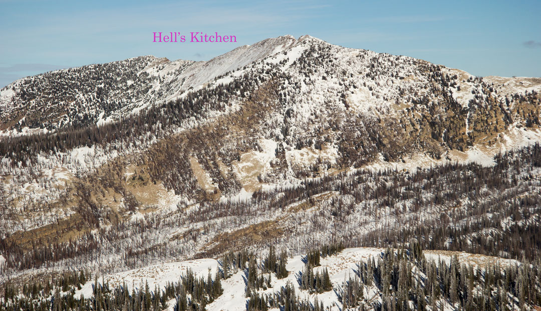
Smith and Moorehouse Hell’s Kitchen (right, not seen in photo)

Fresh snow Ledge Fork Campground
Day 2
After some hot coffee and breakfast, we’re fueled up and ready to climb 3,000 ft and ski over 4 miles to HELL’S KITCHEN.
Leg-2) 1.25 miles 220ft elevation gain to a creek crossing (40 minutes to footbridge)

Kota reluctant to Cross on an icy footbridge
Leg-3) Footbridge to Summit 3 miles 2,803ft elevation gain to Top Hell’s Kitchen.(3hr20min)
")
Entrance to Hell’s Kitchen
Shortly after crossing the creek, the mountain walls steepen forcing the trail down into a steep stream bed. This is where Uinta backcountry skiing got dicey. The sound of the water rushing under the snow was quite intimidating while skinning over snowbridges.

My ski partner is a Rottweiler and snowbridges don’t hold Rottweilers like they do backcountry skiers. I decided to find a different route, lookers right of the creek

Bushwhacking Snagglefest!
The woods in this area are riddled with downfall, making travel difficult. After a couple of hours of bushwhacking, I end up back in the creek. We pushed on a bit further but we eventually turned around.

Back to Camp

I pack up, skin out, and drive home to Park City.
Uinta backcountry skiing hells kitchen
Tour Plan Uinta backcountry skiing (Hell’s Kitchen) with an estimated time of travel.
Leg-1) 3.5 miles 420ft elevation gain to Ledgefork campground. With a full Pack, (2.5hrs)
Sunrise 7:06 am – Sunset 7:55 pm (12hrs 46min daylight)
Leg-2) 1.25 miles 220ft elevation gain to a creek crossing (40 minutes)
Leg-3) 3 miles 2,803ft elevation gain to Hell’s Kitchen summit. (3hr 20min)
Leg-4) Reverse leg-3 (1hr.25min)
Leg-5) Reverse leg-2 (35min)
Leg-6) Reverse leg-1 with full pack (2.5hrs)
Total estimated Day 2 travel time (8hrs 20min) Rest and Base Camp breakdown time (4hrs 26min)
Tour notes
-Take the main Smith and Moorehouse trail. Just over a mile then Bushwack left towards the river.
-Somewhere on the shore you’ll come across a makeshift log footbridge. Be very careful.
-Stay in the stream bed or it’s Snaggle-fest.
-It gets a little Closter-phobic in the narrow steep stream bed. 1.5 miles
-Then it opens up and flattens out. This is Hell’s Kitchen basin where several small lakes and most prominently, Jean Lake.
Jean Lake seems like a possible place to set up Camp. Far enough away from possible avalanche paths
-I made camp at Ledger Fork Campground. (had access to facilities -el bano-)
Maps
Uinta 1 by Alpentech 2002
Click on photos to see the full gallery.
This Trip Report is: To Be Continued.
See Weber Canyon Uinta Backcountry ski photos
For more see: